| Scanning a storm area
The conical beam of the weather radar sweeps up
targets left and right of the aircraft centreline. This positions the
azimuth of the storm area, and that position is incorporated with the
distance to “paint” a two dimensional image on the screen. Through the
tilt control knob, the pilot can better examine the storm in the vertical,
relating various degrees of precipitation to the aircraft’s current
level. The tilt knob is arguably the most important control function
available to the pilot. Tilt knob use is essential if ground returns are
not to be painted at differing aircraft attitudes and altitudes. The use
of the tilt knob is a study in itself (refer Wx radar 14).
|

Fig Wx radar 14. Radar provides slices of storm
characteristics.
|
| When radar
energy encounters a precipitation particle some of the energy is absorbed,
some returns to the receiver, and some is scattered in various directions.
Different types of precipitation have widely differing rates of
reflectivity. Weather radar does NOT detect non rain bearing cloud, fog,
or clear air turbulence (CAT). It does detect wet hail and large raindrops
very well. A large amount of microwave energy is reflected by wet hail and
large raindrops, whereas dry snow does not reflect energy, scattering it
instead, mainly away from the receiver. Knowledge of the degree of
reflectivity of the various precipitation types is a must for the ATPL
exam.
Refer Wx radar 15.

 |
Beamwidth
This describes degrees between the edges of
the beam. At 60 nm distance from aircraft a 3 degree beamwidth is
3nm across, and at 120 nm it is 6 nm across. This can lead to two
distant storms that are close together being painted as one large
storm. As the aircraft gets closer to the storms, they eventually
resolve into two separate storms, once the distance between them is
greater than the beamwidth at that range.
(refer fig Wx radar 16)
|
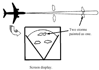
Fig radar 16. Beamwidth can effect storm resolution.
|
|
Thunderstorm
avoidance distances
You should NOT attempt to fly over the top
of a thunderstorm. If no other option is available, the minimum
vertical clearance is generally accepted as 1, 000 ft for every 10
kt of wind blowing at the cloud top.
Any lateral clearance of an
area painting contours should be at least 20 nm. Preferably pass on
the upwind side of the storm, as storms can move faster than you may
think, and hail from the anvil can extend many miles downwind. Fig’s
radar 17a and 17b show the hail damage to a Cessna Citation which
occurred outside the cloud in supposedly clear air. Images supplied
by BASI.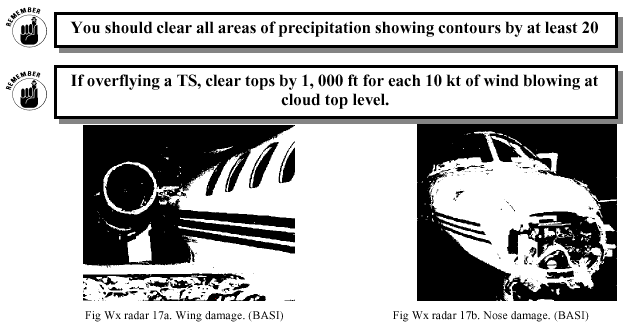 |
|
Ground
Mapping
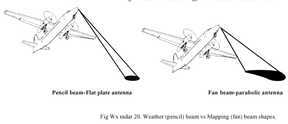
In addition to scanning for hazardous
precipitation indicative of turbulence, you can operate in ground
mapping mode. In those systems using a parabolic dish, the beam is
changed to a fan shape (refer Wx radar 20). Those using a flat plate
antenna are not re-shaped. Prominent features such as lakes, cities,
coastlines, islands and mountains can be distinguished, which can
prove to be a good gross error navigation check. The relative
brightness or colour of returns varies considerably dependant on the
type of terrain. Water is generally planar, and largely reflects
radar energy away from the aircraft. This means that water paints
black on the screen (refer fig Wx radar 18). On the other hand, land
shows up varying degrees of return brightness/colour, and so
coastlines, rivers, and lakes show up with good clarity. Strongest
returns are those from irregular objects such as buildings and steep
rocky hillsides. Refer fig Wx radar 19.
|
|
One limitation to the use of weather
radar for ground mapping is that when approaching a range of hills
or mountains. The radar screen can show black areas (radar shadows)
behind the hills which may appear to be lakes. This can be a little
worrying when your planned track does not involve overflying any
lakes. As the aircraft gets closer to the hills, the radar shadow
which appears as lakes will be resolved, and the phantom lakes will
disappear. |
 |
|
|
|
Best wishes
Rob Avery

Marty says ... "Goodbye to GA".
|
|