


|
|
|
|
Aircraft Systems Topic 16.
Weather Radar - Part 2
| The shape of a storm can indicate the severity of
turbulence and precipitation. Knowledge of hazardous shapes is essential
for the ATPL examination, and real life.
Dangerous storm shapes |
||
 |
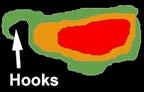
Hooks: These are indicative of a tornado, and are most likely to occur in thunderstorms with a marked horizontal windshear in the middle levels of the cloud. Any return from a tornado will be weak, as they contain little moisture (refer fig Wx radar 6). |
|
|
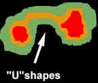
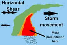
“U” shaped returns: These indicate a strong updrafts bounded on three sides by heavy precipitation which is associated with likely downdraft's. Penetration here could risk vertical shear that exceeds the structural integrity of the aircraft (refer Wx radar 7). |
|
|
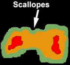
Scalloped edges on back side of storm: These
are indicative of severe attenuation of the radar energy due to extremely
heavy precipitation. True extent of turbulence and storm size is NOT being
displayed (refer fig Wx radar 8).
|
|
|
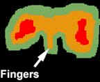
Fingers: Another sign of a severe thunderstorm. Generally the more contorted the shape of a return, the greater the risk. Sharp contours are likely indicating a growing storm, while fuzzy contour edges often indicate a storm in the dissipating stage (all downdraft's). Refer fig radar 9. |
|
|
Pendant shaped storms: If displaying all levels of
precipitation, this is indicative of a “leaning (steady -state)
thunderstorm”, also called a “shear thunderstorm”. It is a variation
of any other type of thunderstorm, but is most common at cold fronts and
in squall lines. They may contain cricket ball size hail. They are
considered the most deadly type of thunderstorm, and penetrating one can
be likened to jumping into the sea next to a hungry Great White Shark.
Refer fig Wx radar 11. |
|
| Aircraft with EFIS cockpit
instruments usually have the weather radar return overlaid into the “Electronic
Horizontal Situation Indicator” (EHSI), whereas aircraft with
conventional cockpit indicators have a separate radar screen, such as that
indicated in fig radar 5.
Monochromatic types feature a mode called “Iso-Echo Contour mode”. When this button is pressed, areas of precipitation corresponding to red on a colour screen, turn black. This leaves the lighter green portion around the black area so that changes in rainfall intensity can be better evaluated. A thin line of green indicates a rapid change in rainfall rates (steep rainfall gradient), and such an area should NOT be penetrated because of the inferred high degree of turbulence. (refer to fig Wx radar 10)
|
|
||||||||
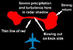
| Thin lines of red:
Often seen connecting two large strong returns, and bowing out on the back
side. This indicates that a massively powerful thunderstorm may lurk in
the black, and apparently benign area behind the thin line of red. Radar
energy is being attenuated (weakened) so badly that it can NOT get back to
the receiver to advise you of the real danger. Basically, submarines are
NOT made to go through this much water. If radar energy travelling at the
speed of light cannot penetrate and successfully return from the storm,
you have little hope at 500 knots. The area behind the red, being black
and showing no return is called a “Radar Shadow”
(refer fig’s radar 11 and 12).
A radar shadow can result from an attenuated signal from a nearby storm, masking a larger and more dangerous storm behind. You may not be aware of the storm behind until you clear the first, and are about to penetrate the second. By such time evasive action may not be possible (refer to fig Wx radar 13).
Fig Wx radar 13. Radar shadow masks lethal storm behind nearest storm. In the next instalment on Wx radar, we will look at the varying reflectivity of precipitation types, beamwidth effect, ground mapping, and recommended thunderstorm clearance margins. Best wishes Rob Avery
|
|||||||||
![]()