


|
|
|
|
Aircraft Systems Topic 24.
B767 EFIS Plan Mode
| Overview
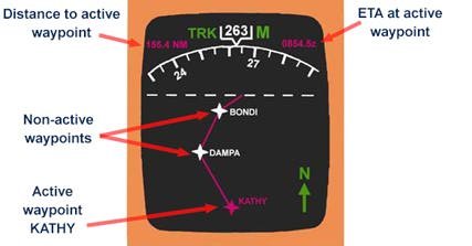
This mode allows the crew to step through the flight route, and verify it’s waypoints, and departure and destination airports. It is rather like looking at a simplified enroute IFR navigation chart. Any modifications to the route to be flown can be viewed prior to being executed and becoming active. Orientation PLAN mode provides two screen displays in one. The upper 1/3rd of the screen provides a 70 degree compass arc presentation that can be either magnetic heading or track up, depending on software installed. This compass arc is provided so that a constant display of heading is provided for crew situational awareness during PLAN mode operation. The lower 2/3rds of the screen is oriented true north up, just as on a chart. In fact this part of the screen is representing a simplified IFR navigation chart, showing only those tracks and waypoints applicable to the flight. The dashed line across the screen is for explanation reasons only to divide up the screen orientation – it does not appear on the real screen. The upper display orientation does not align with the lower 2/3rd display, and this can cause some confusion at first. For instance, in the image shown here, the aircraft track is 263M, but the track to the active waypoint of “KATHY” might be misunderstood as being true north of the aircraft when viewing the lower 2/3rds of the screen. In fact if the aircraft symbol could be displayed on screen, it would be about where the true north arrow is, and pointing towards the left of the screen. Aircraft Symbol There is no aircraft symbol shown in this mode.
Waypoints A waypoint shown as a magenta (purple) star is the active waypoint the autopilot/flight management system (FMS) is flying towards. Non-active waypoint are shown in white. These change colour to magenta as the active waypoint changes. Only one waypoint is active at one time. The active waypoint name is displayed in magenta. Non-active waypoint names are in white. Distance to, and ETA at the next waypoint is shown at the top of the screen in magenta. Active route The FMS active route is shown as a solid magenta line connecting the waypoints. Inactive routes are displayed as white lines. Active route modifications are shown as short dashed white lines between the waypoints. Activating the route modifications changes the line to solid magenta. Should a deliberate off-set route be loaded and activated into the FMS, it is displayed as an alternate dot-dash magenta line, parallel to, and off-set from the active route. Range arcs/weather returns These can not be displayed in PLAN mode. Weather returns can not be displayed either. Holding patterns These are displayed in magenta if active, cyan if inactive, and white if modified. Modified or inactive holding pattern turn to magenta if/when they become active. Route data Pressing the route data switch on the HSI selector panel, will display the ETA at each waypoint en-route. This assists in updating ATC or passengers as to any changes to ETA due to differing winds that may be encountered. Airports and Navaids These can be displayed if the appropriate HSI selector panel switches are pushed. This mini-editorial is an abbreviated sample from the book “Flying Glass”, and from the soon to be released online ATPL “Aerodynamics and Aircraft Systems” course. Knowledge of EHSI modes form part of the Australian Civil Aviation Safety Authority (CASA) ICAO ATPL syllabus. For more information go to http://www.aviationshop.com.au/avfacts/Study_texts.htm This is one of a series on the B767 EFIS displays - check the editorial index for the others. An interesting website within Boeing is that related to the quarterly AERO e-magazine. One particular article to complement what you have read here can be found at: http://www.boeing.com/commercial/aeromagazine/aero_09/flight_story.html This e-magazine number 9 includes details of the new B767-400 flight deck. For a little fun, be sure and try your hand at the interactive aircraft identification quizzes. A link is provided from the HOME page. A link to a daily aviation news service is also provided on the home page. Best wishes Rob Avery ATPL Instructor
|